 Mountains for hikers & skiers
Home › New Hampshire › Mount Washington
Mountains for hikers & skiersNH 4,000-Footer
⛰ Presidential Range · within the White Mountains
Summit elevation: published (Wikidata / USGS GNIS).

No lift-served ski area on this mountain. Nearest ski area: Wildcat Mountain, about 3.3 miles (straight line).
Backcountry: Tuckerman Ravine and Huntington Ravine on Mount Washington are famous spring backcountry ski terrain. Avalanche forecasts are issued by the Mount Washington Avalanche Center. Mount Washington Avalanche Center.
| Mountain range | Presidential Range · within the White Mountains (Wikidata) |
|---|---|
| County | Coos County |
| Town / township | Sargents Purchase |
| Getting to the top | Drivable road: Mt. Washington Auto Road, a privately run road with a fee; open seasonally, so check its road status page. Official site Cog railway: The Mount Washington Cog Railway has climbed to the summit since 1869. Official site |
| Summit | 6,289 ft / 1,917 m |
Base map: USGS The National Map (public domain). Switch to OpenTopoMap with the layer button. Use for orientation only; carry a proper map and compass.
Loading the National Weather Service forecast for the summit…
Full NWS point forecast for Mount Washington
Mount Washington Observatory higher summits forecast (the best source for above-treeline conditions)
Forecast: National Weather Service (api.weather.gov), for the 2.5 km forecast grid cell at the summit coordinates, which accounts for elevation. Mountain weather changes fast; check again before you go.
Mount Washington State Park.
Land unit from the USGS PAD-US database at the summit point; ranger district from USDA Forest Service boundaries. Office address and phone from the Forest Service offices page.
The nearest Forest Service trailheads:
Trailheads: USDA Forest Service. Pass requirement: WMNF list of fee sites; at other trailheads we don't know of a fee. Check the official page before you go.
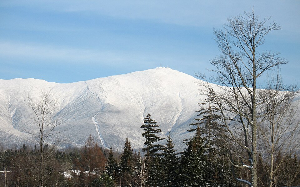
Views: Open, above-treeline summit; treeline here is as low as about 4,400 ft because of the extreme winds. The Tuckerman Ravine Trail's rock steps give views of the ravine and across Pinkham Notch to Wildcat Mountain.
Popular hike: Tuckerman Ravine Trail from the Pinkham Notch camp area (NH Route 16), gaining about 4,280 ft. Check current trail conditions and the AMC White Mountain Guide before you go.
Source: Wikipedia, “Mount Washington”.
Calculating…
Calculated in your browser for the summit coordinates (standard sunrise equation, Eastern Time). From a high summit with an open horizon, the sun appears a few minutes earlier and sets a few minutes later than the sea-level times shown here; the extra minutes are estimated from the summit's height.
Mount Washington is notorious for its erratic, extreme weather, with hurricane-force winds possible in any month. Check the higher summits forecast and be ready to turn back. (source)
Consider a hikeSafe card. It's sold by NH Fish and Game and helps cover the cost of a search and rescue if you need one, under NH rules. Carry the ten essentials, tell someone your plan and know when to turn back.
Within 15 miles, straight line. Data © OpenStreetMap contributors. Check with the operator for reservations, fees and seasons.
| Town | Typical home value | Median household income | Population |
|---|---|---|---|
| Sargents purchase | — | — | 45 |
| Randolph | $403,128 (Zillow, 2026-09; +9.1% in a year) | $101,750 | 420 |
| Gorham | $247,656 (Zillow, 2026-09; -3.0% in a year) | $61,275 | 2,682 |
| Jackson | $647,184 (Zillow, 2026-09; +6.5% in a year) | $117,986 | 897 |
Home values: Zillow Home Value Index (ZHVI), typical home, as of the month shown; when Zillow has no figure for a town, we show the Census ACS 5-year median home value (table B25077). Income: U.S. Census Bureau ACS 5-year 2020–2024 (via Census Reporter), table B19013. Population: same ACS 5-year release, table B01003.
Recent headlines from Google News, last 90 days. We link to the publishers and don't copy any article text.
Straight-line distance.
133 named lakes and ponds within 30 miles: 31 with a public boat launch, 13 with a public swimming beach.
Straight-line distance from the summit. Lakes and towns: NH Fish and Game fishing guide data. Boat launches: NH Fish and Game public access sites. Swimming: NH Fish and Game access sites and NH DES monitored public beaches. No badge means access is unknown, not that there is none. Check local rules before you go.
Straight-line distance. Data © OpenStreetMap contributors.
67.9 miles of USDA Forest Service–managed trail: the full length of every USFS trail segment that comes within 2 miles of the summit (computed from USFS trail GIS data).
| Trail (USFS name) | Total length |
|---|---|
| Dry River Trail | 8.4 mi |
| Crawford Path | 7.7 mi |
| Tuckerman Ravine | 3.8 mi |
| Glen Boulder | 2.8 mi |
| Wamsutta | 1.6 mi |
| Lions Head | 1.2 mi |
| Mt Monroe Loop | 0.6 mi |
| Lawn Cut-Off | 0.4 mi |
Lengths are each trail's full mapped length in USFS GIS data, not a summit route. Difficulty ratings are not published in this data, so we leave them out.
| Mid-month | Sunrise | Sunset | Turn around by* |
|---|---|---|---|
| Jan | 7:17 AM | 4:29 PM | 2:29 PM |
| Feb | 6:46 AM | 5:12 PM | 3:12 PM |
| Mar | 6:59 AM | 6:49 PM | 4:49 PM |
| Apr | 6:03 AM | 7:27 PM | 5:27 PM |
| May | 5:19 AM | 8:03 PM | 6:03 PM |
| Jun | 5:00 AM | 8:30 PM | 6:30 PM |
| Jul | 5:14 AM | 8:27 PM | 6:27 PM |
| Aug | 5:47 AM | 7:52 PM | 5:52 PM |
| Sep | 6:22 AM | 6:58 PM | 4:58 PM |
| Oct | 6:58 AM | 6:03 PM | 4:03 PM |
| Nov | 6:40 AM | 4:19 PM | 2:19 PM |
| Dec | 7:13 AM | 4:06 PM | 2:06 PM |
Computed for the summit coordinates with the NOAA solar formula, Eastern Time (DST applied). *Rule of thumb: be heading down at least 2 hours before sunset; start early enough to reach the summit before this time.
Sep — the month with the fewest wet days (≥1 mm precipitation) among months where the average summit high reaches 50°F.
| Month | Avg high | Avg low | Wet days |
|---|---|---|---|
| Jan | 9°F | -8°F | 39% |
| Feb | 11°F | -7°F | 42% |
| Mar | 19°F | 2°F | 42% |
| Apr | 31°F | 14°F | 48% |
| May | 45°F | 27°F | 46% |
| Jun | 53°F | 37°F | 53% |
| Jul | 58°F | 43°F | 55% |
| Aug | 56°F | 41°F | 50% |
| Sep | 51°F | 34°F | 34% |
| Oct | 38°F | 24°F | 44% |
| Nov | 25°F | 11°F | 40% |
| Dec | 15°F | -1°F | 46% |
2006–2025 daily ERA5 reanalysis from the Open-Meteo archive, adjusted to summit elevation. Reanalysis smooths mountain weather; summits like Mount Washington are often colder and windier than shown.
Check the USFS trailhead page for parking rules and any recreation pass required.
Hike + ski pairing: hike Mount Washington in summer or fall, then come back in winter to ski Wildcat Mountain, 3.3 miles away.
Summit location: Wikidata Q572801 / USGS GNIS 871352. Elevations: Wikidata/GNIS and USGS 3D Elevation Program (EPQS). Trails & trailheads: USDA Forest Service EDW datasets. Ski stats: Ski NH. Climate: Open-Meteo archive (ERA5). Airports: OurAirports. KOA locations: OpenStreetMap contributors.
